|
|
|
Astral Imaging at Dogwood Ridge Observatory |
Latitude: 37°48'51.0" N" |
|
|
|
|
|
|
|||
 |
|
|
|
||
|
|
|
|
|||
|
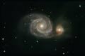
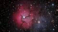
(click on thumbnails to go to that image's page)
|
|||||
| ||||||||||||||||||||||||
|
|
Alaska Trip Glacier Bay National Park
These are pictures we took at Lamplugh Glacier. Stats: From Wikipedia, the free encyclopedia
Lamplugh Glacier is an 8-mile-long (13 km) glacier located in Glacier Bay National Park and Preserve in the U.S. state of Alaska. It leads north to its 1961 terminus in Johns Hopkins Inlet, 1.4 miles (2.3 km) west of Ptarmigan Creek and 76 miles (122 km) northwest of Hoonah. The glacier was named by Lawrence Martin of the U.S. Geological Survey around 1912 for English geologist George William Lamplugh (1859–1926), who visited Glacier Bay in 1884
|
| |||||||||||||||||||||||||||||